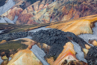
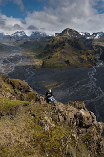
Landmannalaugar looks extremely Icelandic not because most of Iceland looks like this (it doesn’t), but because Iceland is practically the only place you will see landscape like this.
The cascading ranks of bare-sided rhyolite mountains look a bit like a massive cake spackled with cream caramel icing, over which occasional streaks of garish food colouring have been indiscriminately flicked. It might be easy to believe for a while that this was the site of a huge industrial accident which has poisoned the land and killed it totally.
But it won’t take long to see through the lie, as the valleys and plains between the mountains are coated in lush grasses and meadow flowers; the slow-to-depart snow patches on the peaks are pearly white; the birds, tourists and other creatures are evidently in the peak of physical health; and the lakes, ponds, and rivers are pristine and pure.
Organized tour or do-it-yourself?
We always recommend that you travel by yourself but in the case of Landmannalaugar we suggest that you book an organized tour if:
a) You want to travel in winter as it is impossible to do it with a normal 4x4.
b) You do not have a 4x4 vehicle (It is forbidden to drive to Landmannalaugar without a 4x4 car).
c) You have no experience driving on gravel roads and/or crossing river.
d) You are traveling with a motorhome or a camper.
Here is a link for a company that specializes in tours to Landmannalaugar. If you want to save money, there is a 4x4 bus with a price of 14.500 ISK per person everyday from Harpa (Reykjavík).
The rivers are hot, however – which is one of Landmannalaugar’s biggest attractions. The name Landmannalaugar could, in fact, be translated as Pools of the People, due to being such a fantastic (and free) place to bathe in natural warm water.
Landmannalaugar is in the Highlands and therefore not easy to get to – and totally inaccessible between roughly October and May. But one of the three ‘roads’ leading to this magical place is juuuuuust about suitable for normal two-wheel drive cars in the summertime. Although maybe not your own car, if you love it!
There are limited facilities in the area, including huts to sleep in, a campsite, a very basic shop, and scheduled coach services passing through from time to time. This puts some people out of their comfort zone, while others find it all far too much. As probably the busiest and best-serviced place in the Icelandic Highlands, the former group will have to resign themselves to the fact that it doesn’t get any better – while the latter group can rejoice that it doesn’t get any worse.
Whichever group you fall into, Landmanna- laugar is a crazy and unique place you will want to visit at least once. Climb a red or purple mountain, see for many tens of kilometres in every direction, relax in the hot streams, revel in being in the middle of nowhere (even if there are a fair few other people there with you). Landmannalaugar is even allegedly the best place in Iceland to see the northern lights.
The reason for this is that there is absolutely no ambient light pollution, that you absolutely have to be soaking in the hot water while gazing upwards, and that the colours and shapes of the lights match the landscape like nowhere else. Pure heaven! But it’s really only late August and September, when the area is still accessible and the nights actually get dark, that you’ll be able to indulge in this surreal pleasure.
How to get there
With a bus: There are daily tours to Landmannalaugar from Reykjavík from the middle of June to the middle of September. Departure from BSÍ (omnibus central station) at 8:30. There are also daily tours from Skaftafell. The busses stop for 2 hours in Landmannalaugar and leave to Reykjavík and Skaftafell around 14:30 (changable schedule!). In the mid summer there are scheduled bus tours between Landmannalaugar and Mývatn. Reservations are not necessary.
Informations:
Tel. +354 77-444-77
Driving a car: You can take your own car to Iceland with the ferry or rent a car in Iceland. Insurances do not pay for damaged rental cars on F roads (mountain roads). There are three main roads leading to Landmannalaugar. The easiest one is F 208 from the north, from the power stations. There are no rivers to cross, so a normal car will be enough, but be prepared for some shaking. You need bigger cars, with 4Wd for the other roads. The second easiest is F 225 from the west (close to mt. Hekla) and the third easiest is F 208 from the south (between Vík and Kirkjubæjarklaustur). Inform yourself about the weather because water in the rivers can differ a lot.
Landmannalaugar Tours: You can let experts do the driving and carry the responsibility (Day Tours every day; +354 776 76 76, www.landmannalaugartours.com). A Super Jeep Tour to Landmannalaugar cost around 38.000 ISK (summer and winter).
Some people hitchhike but that requires patience, since most drivers in the highlands are using all their space.
Biking: This is cheap but can be very difficult. Weather can be awful and some roads are so sandy that they are too loose to bike in. The sceduled busses can take bikes for reasonable fee. You use the same roads as the cars. Biking on the Laugavegur hiking trail is not forbidden, but only suitable for trained mountain-bikers, who can take care of not spoiling the tracks and the land.
Hiking: Almost everyone who walks to Landmannalaugar follows the Laugavegur trail from Þórsmörk. It takes 3 or 4 days and there are huts on the way. There are bus connections at both ends. Hiking daytours around Landmannalaugar are many and magnificent.
Where you can sleep
Camping: In the nature reserve area, you may only camp at Landmannalaugar, Landmannahellir and Hrafntinnusker. Outside the area you may camp anywhere where you don´t spoil anything. There are camping facilities where there are huts and there you have to pay something.
Hiking trail Landmannalaugar - Thorsmork
The total hiking distance is close to 53 km and the route from Thorsmork to Skogar on the south coast adds 24-26 km.
The Landmannalaugar - Thorsmork route is called „Laugavegurinn", The Hot Spring Route, which is very appropriate. It is clearly marked between the huts in Landmannalaugar, Hrafntinnusker (Obsidian Skerry), on lake Alftavatn (The Lake of the Whooper Swans) and on river Sydri-Emstrua in Fremri-Botnar.
The trail "Laugavegurinn" is one of the most popular and most travelled hiking trails in Icelandic wilderness. It is equally popular with domestic and foreign hikers. This is not without a reason as the trail offers a great variety of landscape. Mountains in almost every colour of the rainbow, great glaciers, roaring hot springs, big rivers and lakes. Generally the hike lasts four days and the starting point is Landmannalaugar (altitude approx. 600 meters) Overnighting is in huts but you have to supply your own sleeping bag. Those with confirmed reservations have a higher priority so it is important to look in aðvance if you want to have a certain place to stay.
1. day: Landmannalaugar-Hrafntinnusker
Distance 12 km, estimated walking time 4 - 5 hours. Elevation increase 470 meters.
From the hut in Landmannalaugar (75 persons, GPS 63°59.600 - 19°03.660) the trail goes through a rough lavafield "Laugahraun". From there on up the slopes of "Brennisteinsalda" and to the plateau. The view offers an incredible spectrum of colours. After 3 - 4 hours you arrive at "Stórihver", a hot spring and almost the only green spot visible in the first day. In most years the rest of the trail from "Stórihver" to "Höskuldsskáli" hut is covered with snow. Chances of fog are very high so even though the trail is clearly marked you must be careful. A walk to the icecaves (approx. 1.5km from the hut) is a must. The huts location GPS 63°55.840 - 19°09.700 and sleeps 36 persons.
2. day: Hrafntinnusker - Álftavatn
Distance 12 km, estimated walking time 4 - 5 hours. Elevation decrease 490 m.
The first part of the trail takes us through a valley with some small ravines but be careful as they may be filled with snow. If the visibility is good a walk up to the top of mountain "Háskerðingur" (1281 m) will reward your with a breathtaking view. Soon we leave the colourful rhyolite mountains and enter an area with dark palagonite mountains and glaciers. You will also notice a considerable increase in vegetation. The trail down the "Jökultungur" is rather steep but leads down to a friendly oasis on the banks of river "Grashagakvísl" a fine place to rest for a while. From there on the trail to the two huts by the lake "Álftavatn" is on flat land. There are two huts (58 persons, GPS 63°51.470 - 19°13.640).
Distance 15 km., estimated walking time 6-7 hrs., elevation decrease 40 m.
The trail takes us over the ridge "Brattháls" into "Hvanngil" ravine, wading across the river "Bratthálskvísl". In "Hvanngil" are two huts, one built for sheepherders in 1963 and one for tourists, built in 1995. A short walk from the huts is the river "Kaldaklofskvísl" with a bridge for hikers. On the eastern bank of "Kaldaklofskvísl" the trail branches, one branch leading eastwards to "Mælifellssandur" (Road F 210) but the other one southwards to "Emstrur" and we choose the latter. Less than one km from "Kaldaklofskvísl" another river has to be waded and approximately 4 km further we come to the river "Nyrðri Emstruá" but this time there is a bridge to cross it. Soon we will be overlooking the huts in "Botnar" (40 persons, GPS 63°45.980 - 19°22.480). A fine walk in the evening is to the "Markarfljótsgljúfur" canyon.
Distance 15 km., estimated walking time 6-7 hrs., elevation decrease 300 m.
First we have to go around the canyon of "Syðri - Emstruá" and there is a very steep path down to the bridge so be careful. Then a walk through the area known as "Almenningar" with crossing of among other rivers "Þröngá". It is good practice when wading to go hand in hand and head downstream. After crossing "Þröngá" a 30 minutes walk takes us to the hut in "Langidalur" in "Þórsmörk" (75 persons, GPS 63°40.960 - 19°30.890) Landscape and vegetation is changing rapidly. Birchwood and all kinds of plants a welcome change after the desert now behind us. The hut in Thorsmork is Basar huts in Godaland, in Langidalur Hut Skagfjordsskáli and cottages and huts in Husadalur.
Jóhanna Rós & Kolla
© 2016 WhereToGoInIceland.blogspot.com


